Where are we?
Guidebook's Australian Maps
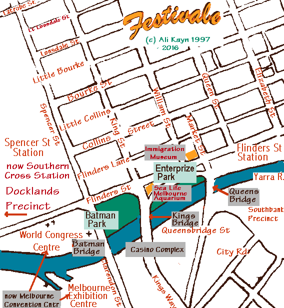
Map of Melbourne Central District towards Spencer Street and the Convention Centre
Victoria, Australia
The heavily revitalised Spencer Street area is close to a number of inner city dwellings as well as offices and shops. Past Spencer Street lies the Docklands Precinct. The City Circle tram no longer runs along Spencer Street as it now goes into the Docklands.

| Items of interest: | Southern Cross Railway Station (previously Spencer Street Station - interstate rail travel and city loop trains), Flinders Street Railway Station (suburban rail travel), Queens Bridge, Kings Bridge, Batman Bridge, World Congress Center (now Melbourne Convention Centre with the Melbourne Exhibition Centre (center) (also known as Jeff's Shed, Crown Casino Complex, Yarra River, Batman Park, Enterprize Park, Immigration Museum, Sea Life Melbourne Aquarium Little Bourke St, Bourke St, Little Collins St, Collins St, Flinders Lane, Flinders street, Spencer St, Kind St, William St, Market St, Queen St, Elizabeth St, Queensbridge St, City Rd, Kings Way, Clarendon St, Southbank Precinct |
| Related maps: | Melbourne central district map, towards Carlton Gardens |
| See also:
|

For posts about Melbourne events, places, news, reviews, giveaways, see our Facebook Page:


 Published in Melbourne, Victoria, Australia